Just thought we’d let everyone know what GPS we use!
We’ve tried a few GPS apps for our phones and tablets, but I (Daniel) as the main driver, really wanted something that just stayed in the truck, was always on when we were driving, was easy to read and to use. So I started researching GPS units.
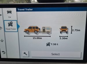
We ended up with the RV890 from Garmin, which has been fantastic. We can enter all our vehicle parameters (Length, Weight and Height) and it tries to route us away from roads that aren’t suitable for us. (Or warns us if the only route isn’t suitable for whatever reason).

The map is great and it comes preloaded with the HEMA 100k raster map and the Garmin map. (We use both) My favourite feature is the Altitude. When I press the button it shows me the altitude changes along our route, basically hills up and down along with the steepness. This lets me prepare for big and steep climbs or descents before they happen!

We can highly recommend this GPS unit to other travellers.
If you enjoyed this blog or found it useful, please feel free to click on any of the ads on the page, it doesn’t cost you anything, but it does help us see a little money to cover the hosting costs of the website.
Further, if you are looking to support us in other ways, you can buy a product from our Travel Tools Page, purchase a piece of Dan’s photography art or ‘buy us a coffee“.
We also offer one-on-one travel consultations, via video calls. If you wish for further information, clarification or personalised advice for something specific to your travel needs, feel free to book a session to chat with us.
Finally, don’t forget we have heaps of other helpful blogs for travelling Australia on our website, plus so much more!
Disclaimer: I may make a small commission if you buy from our links on our website, it just helps us cover the costs of the website to have this info available for you and costs you nothing more.
Thank you for your information. Very informative and useful. Is it got good off road mapping as well? I am so use to using garmin.
Hi Chris,
Yep, it runs the HEMA maps, so it’s excellent.
Thank you. Very helpful.